More and more folks are using GPS's in their outdoor activities. If you read my previous article, Montana, the latest Adventure Touring GPS!, you hopefully realized how handy a GPS can be. Trip Planning is an essential activity to insure a safe and enjoyable outing. No matter how you do your planning, whether it's taking a good look at a paper map and tracing your route or using an online service such as Google Maps, you will be better prepared and most likely will have a more enjoyable adventure. When it comes to Motorcycle Adventure Touring, we've been pushing the planning envelope for years because of the length and location's of our Tour's. We rely upon GPS's to provide our clients the freedom to venture out on a daily basis so they don't have to, or need to, follow a guides rear wheel. That freedom of adventure is enabled by having enough good data to get to where they need to be at days end - even when digital maps had a lot less detail than they do today.
Over the years, Garmin has provided free Trip Planning software to help enhance the use of their GPS products. From MapSource Trip & Waypoint Manager to the robust version of MapSource we know today. But MapSource was a somewhat difficult application to just "walk up" and use. As the number of Garmin's customers grew so did the number of Apple Mac users. To accommodate this sizable customer base, since MapSource was only available on the Windows OS, Garmin developed RoadTrip. Unfortunately, neither MapSource nor RoadTrip seemed to get the focus from Garmin that customers were looking for.
With new market driven GPS features and services as well as a need to provide planning tools for mulitple land-based user activities, required Garmin needed to take a new approach to computer based trip planning. One where the computer application would have a much closer affinity to the GPS attached to it and it's customer base. BaseCamp for the Mac OS and Windows OS was in customer Beta-testing throughout 2010. The design objective was to create a "walk-up and use" application, while still providing the necessary features needed by more experienced users. With the afore mentioned objectives, BaseCamp could not mearly be a renamed follow-on to MapSource. Although they are similar, in many ways they are very different. This has lead to MapSource user frustration when trying to make the shift to BaseCamp - more on this later. One very refreshing aspect of BaseCamp is discovering that the Development Team is now participating in the Garmin Forums. I think they are doing a great job of listening to "feature requests" and helping with some bug issues. To be clear though, they are not Product Support. Now if only the Garmin GPS brands would participate in Garmin Forums.
Like the applications before it, Garmin does not charge for BaseCamp. New Garmin Map products on DVD install BaseCamp as the default map rendering application and it will usually be installed automatically on whatever OS you happen to be using if you haven't already installed it.
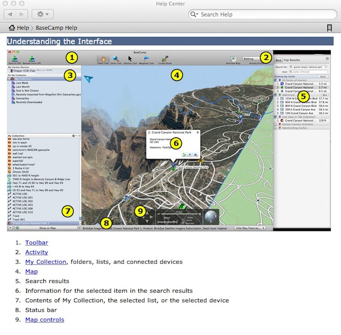
Because of the differences in tool method's and some processes between the two BaseCamp's, I am not going to try to put a step-by-step "how-to" tutorial into words here. If you're new to BaseCamp on either OS, I suggest that you install it on your computer and read through the BaseCamp Help file - it actually will "help". Then start using the Tools to create Waypoints, Tracks and Routes. I've heard that the BaseCamp Development Team is working on video Tutorials for each of the BaseCamp's but there is no announced availability.
Help is - helpful!
 |
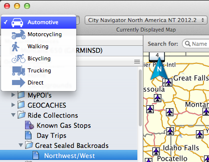
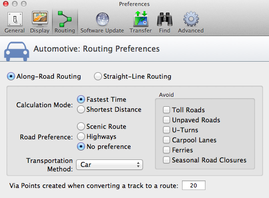
I introduced Garmin's Activity Based Profiles in my Montana article. This is a concept that will hopefully be available in all of Garmin's Consummer GPS's in the near future and BaseCamp is very much in-step with the GPS Brands. So, what do these Activities do for you in BaseCamp? Very simply, you pick an Activity from the list and then set your Preference or Options settings. All of these settings will be saved to that Activity profile. As an example, in my Automotive and Motorcycle Activities, I have my Topo Maps set to not show contour lines. While in my Walking Activity profile the contour lines do show on the map. Other key settings that an Activity can save are your Routing preferences. I highlight this one because for so many years sharing a Route from one person to another has been of little value due to inconsistancies in how the GPS would calculate the Route. As time goes on, more and more of the Garmin GPS's will use this Routing Activity information that is passed along with the Routing data. Hopefully, this will take some of the "I hope it routes the way I planned it" anxiety out of sharing a route or even using it on your own GPS.
You can quickly change BaseCamp's Preferences or Options by a single click on a different Activity once you have set them up.
|
The Activity Preferences or Options settings are also saved in your BaseCamp Backup's |
Since the first production release at v3.2, the two BaseCamp's version level's have remained the same. Although there has been some convergence in the general user interface design with the latest version (v3.2.2), the Tools, Tool methods and some of the data management features are still quite different. According to one communication I had with the Development Team, they are trying to relate to the User's expectations on the two different Operating Systems. An admirable design objective but I think as more and more folks use both of these applications the features and functions will start to look and feel more and more alike. Mainly because the data we create and what we do with it are the same on either OS. A Waypoint is a waypoint, a Route is a Route and a Track is a Track irregardless of the Operating System.
The following are good examples of some of the "differences" in the Tools, Tool methods and the data management - all of which could change over time.
BC-Mac Tools are always available on the Tool Bar to create new. To Edit previously saved objects (Routes/Waypoints/Tracks) you need to open the objects Properties or Right-click on the object in your List.
|
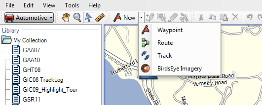
BC-Win Tools for creating a "New" object are accessed via a drop-down list.
|
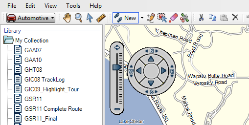
Once you have created a new object in BC-Win, the four edit tools become visible.
|
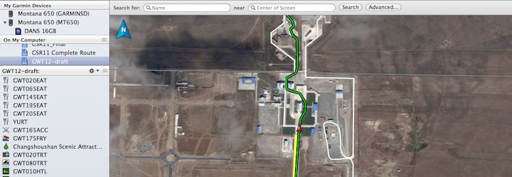
BaseCamp's approach to managing your data is unlike MapSource. MapSource was a document based application where one Opened/Closed/Saved documents (files) and that required you to organize your data (files) outside of the application. BaseCamp has a database approach. BaseCamp keeps all of your data in a database and organizes it inside the application. BaseCamp automatically saves your data when you make changes so no worries about lost data if you have an unexpected "shutdown". You can also Backup your data to a separate location - which I do regularly. Under the "My Collection" folder, you can further organize your data into what are called "Lists". I like to think of these Lists as events or activities for organization and naming purposes. Since this is a database, Lists are just organizational "views" of your data in My Collection.
The Backup & Restore feature has a side benefit. You can create separate BaseCamp "My Collections" and use the Backup/Restore to switch between them. For example, I have two "collections", one for GlobeRiders data and one for my personal riding data. The important part of using this method to seperate your data is making sure you Backup your My Collection after each session incase you decide to do a Restore to another collection at a later date. By the way, a Backup not only saves all of your data but it also save the "organization" of your data: your List's and Folders - should you have them.
Mac Data
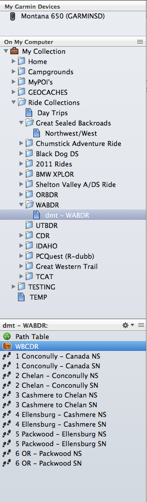
In BC-Mac, My Collection can have any number of List Folders and Sub-folders with any number of Lists in each. |
Windows Data
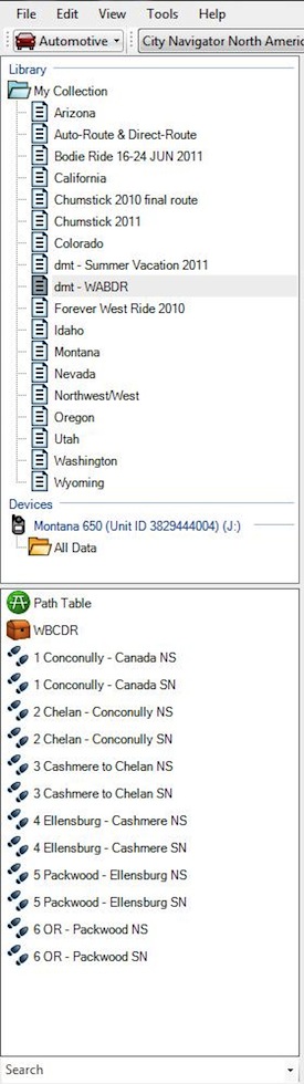
In BC-Win, My Collection does not have the List Folder and Sub-folder feature. Hopefully they will come in the next release.
|
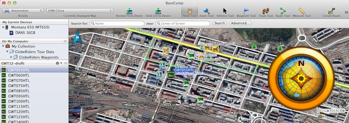
BaseCamp-Mac also has a data feature that allows you to create a virtual "filter" List called a Smart List. A Smart List is another way to create a "view" of your data without duplicating any of the data objects (Waypoints, Routes, etc.). You do this by setting up "filters" for the Smart List. For example, I have a Smart List of all of my Known Gas Stops. If I edit one of the Waypoints in this Smart List it will be updated in the List(s) it is used in. The BaseCamp Development Team says that they are also looking at providing a "Where Used" feature in a future release. This feature would allow you to "right-click" on an object, like a Waypoint, and see where (in what List's) that object is used in your My Collection - a very useful feature in a database application.
If you should need or want to save a portion of your data outside of BaseCamp, you can "Export" selected data as a file in one of several formats (GPX, GDB, etc) depending upon what you want to use the data for. Exporting does not remove the data from your My Collection or the Lists it resides in.
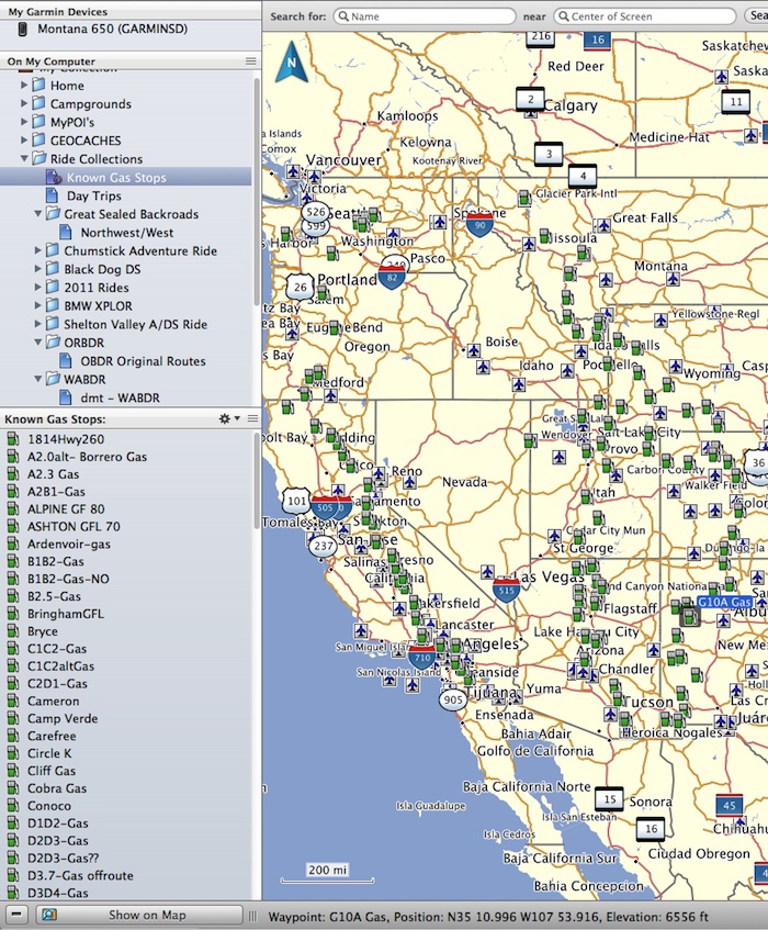
In the screen shot above, the "Known Gas Stops" List is a Smart List and was created by a simple "Waypoint-type" filter on My Collection. |
Trip Planning benefits most from good maps of the area you will be traveling in. At GlobeRiders in years past we only had Garmin's World Map product available to us for planning and for use on our GPS's. Although this product is still available (v5.0) it does not have street level detail and even major roads can be - in the wrong place. We do however still use this product as a kind of backup to whatever detailed maps we can purchase or download for free. BaseCamp, like most of the newer GPS's, does have a basic Global Map although it is somewhat less accurate than Garmin's World Map product. Good maps can be purchased from Garmin or from third parties and I expect that most folks will do just fine with the latest versions of Garmin's City Navigator™ for North America (which includes Mexico) or Europe. We use commercial map products when available. We usually need to acquire them from multiple sources because no one company has high detail maps that cover the globe. Our friends at GPSTravelMaps.com have some really great map products and are continually adding maps to areas of the World not covered by others; like the soon to be released China map. In addition to commercial map products, there are also free maps available for Garmin GPS's and BaseCamp from many sources. We've used some from Open Street Maps, the open source mapping group that relies upon GPS users to provide data to the map creators. These maps don't always have the level of detail or sophisticated finish that commercial maps typically do - but then sometimes any map is better than nothing. These free maps also don't usually have the high level of data compression that newer commercial maps have. Which means they will take up more storage space on you GPS and in BaseCamp.
Garmin has also developed a separate application, MapInstall, for Map installation between BaseCamp and your GPS. When you want to include maps with your Waypoints, Routes, Tracks and other GPS data, BaseCamp will start the MapInstall application for you. MapInstall works very much like map selection did in MapSource - it will enable you to select from the map product(s) you have installed in BaseCamp. As you select areas (segments) of a map, MapInstall will highlight the area you have selected and indicate the file size and the number of map segments you have selected. Sorry, Map Segments are currently only shown in the Mac version. The reason I point out "Map Segments" is because all of Garmin's GPS's, those that allow additional map products to be installed, have a total combined map segment limit. My Garmin Montana 650, for example, has a map segment limit of 4000 segments; irregardless of the number of map product files I load. Unfortunately, Garmin does not publish the Map Segment Limits for each of their GPS's. If you do exceed the map segment limit on your GPS, the map file with the lowest "priority" will not show on the GPS when Enabled. Usually the GPS will not indicate why the map is not showing and it's left to the user to figure out - usually by contacting Garmin Product Support. Hopefully in the future, MapInstall will get a bit smarter and tell us what the map segment limits are of the GPS that is attached.
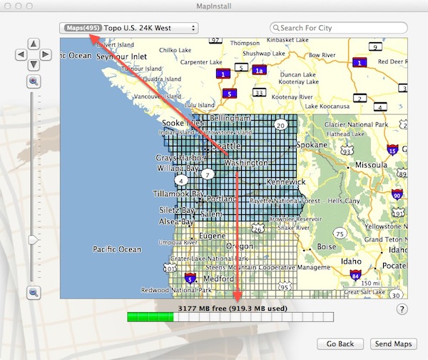
MapInstall-Mac: When map segments are selected you will see the "segment" count next to the map product name. At the bottom of the window is the file size of the selected segments. You can switch between map products if you want to combine maps into one file - but you still can't exceed the 4GB file size. |
One of the new Subscription Service features that BaseCamp supports is Garmin's BirdsEye™ Satellite Imagery. This satellite imagery can be quite handy when map detail is sparse. As you can see below, the BirdsEye Imagery becomes the background to your map data and is geo-calibrated.
On you computer. . . |
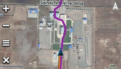
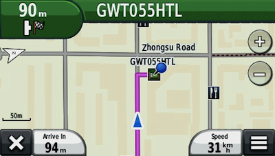
Or, on your GPS! |
That's my overview and I hope you found it informative. Now for my short Editorial on the two BaseCamp's. We're in the age of Online-Applications, where users see the same features, functions and workflow regardless of the Operating System their browser runs in. Trip Planning is not an Operating System dependant activity. There is no reason why the workflow for Trip Planning should be any different on Windows computer than on a Mac. I have to believe it would also be less costly for Garmin if BaseCamp had the same Tools, Tool Methods and Data Management on both OS's. Maybe over time the multiple personalities will merge into one. Oh, and when they do, I prefer the Mac User Interface graphics over the Windows version - said with a smile.
BaseCamp is here and MapSource is no longer being developed by Garmin. Not to worry MapSource lovers, it will be around until the Windows OS will no longer support it - the internet has taken care of that.
To rap up this overview, let's look at a few reasons why a MapSource user might consider moving to BaseCamp?
- It is the Garmin strategic planning application.
- There is a close affinity between BaseCamp and the newer Garmin GPS's from a feature/function perspective while still supporting older Garmin GPS's.
- All of your data is managed by BaseCamp's database. No need to do file management with your trip data outside of the application.
- BaseCamp supports Exporting any portion your data to GPX or GDB formatted files.
- It's easy to Backup & Restore your BaseCamp database and Backup files can be shared between installations.
- Your data is "auto-saved" as you work.
- BaseCamp's ability to use the GPS's "preloaded" maps while the unit is connected to the computer.
On the other hand, there are a few reasons not to move to BaseCamp if you're using MapSource.
- BaseCamp hardware requirements are not insignificant compared to the older PC's that could run MapSource well.
- BaseCamp is a somewhat different application and will require some re-learning.
- BaseCamp is a database that manages ALL of your Trip Planning data. MapSource is "document-based" and you have lots of files with your data in them that YOU manage.
- You have an older GPS that does not support many of the newer features like; BirdsEye Imagery, Photo Navigation, Geocaching.
Ultimately, the longer you use Garmin GPS products the more apt you will be to try BaseCamp but you'll decide when that time is based upon BaseCamp's benefits to you.
I'm in the middle of trip planning for our upcoming 2012 World Tour and yes, I'm using BaseCamp - on my MacBook Air!
If you have comments or questions please send me an email by visiting our Contacts page.
Thanks for your attention.
Sincerely,

Dan Townlsey - Partner/Guide
All Things GPS
|